About RiaaS May 13, 2026
When Road Data Becomes Reliable, Cities Can Act Faster
Dareesoft + Swift Navigation — AI-driven road asset monitoring, live deployment walkthrough
Road signs are more than roadside objects. They guide drivers, support traffic safety, and play an important role in automated enforcement systems. Yet for many cities, knowing whether a sign is present, damaged, blocked, or correctly recorded still depends heavily on periodic manual inspection.
That creates a gap between what the city database says and what actually exists on the road.
Dareesoft built RiaaS — Road Information as a Service — to close that gap. By combining edge AI, vehicle-mounted sensing, cloud analytics, and precise positioning, RiaaS helps transportation agencies turn everyday fleet operations into a continuous road monitoring system.
In a real U.S. city deployment, Dareesoft worked with Swift Navigation to demonstrate how AI-based road asset monitoring can move beyond detection and become trusted, location-accurate infrastructure intelligence.
The Real Problem: City Records Do Not Always Match the Road
Most transportation agencies already have road asset databases. But those records can quickly become outdated.
A speed limit sign may be damaged after the last inspection. A sign may be removed, replaced, blocked by vegetation, or recorded at an inaccurate location. In some cases, the database says an asset exists, but the road tells a different story.
This is not simply a maintenance problem. It is a data reliability problem.
When road asset information is collected only through periodic surveys, cities are always working with a snapshot of the past. By the time the next survey is completed, the data may already be outdated.
For agencies managing thousands of miles of roads, this creates real operational risks:
- Missing or damaged signs may not be discovered quickly.
- Maintenance teams may not know which assets require action.
- Enforcement systems may rely on records that do not fully match field conditions.
- Asset databases become harder to trust over time.
Dareesoft’s goal was not only to detect road assets. The goal was to help cities maintain a live, reliable record of road reality.
AI Could Detect the Signs. The Challenge Was Knowing Exactly Where.
Dareesoft’s edge AI system can detect road assets as vehicles move through the network. Mounted on ordinary vehicles, the system identifies signs, recognizes asset conditions, and flags potential issues such as damage, obstruction, or missing infrastructure.
But detection alone is not enough.
With standard GPS, the same physical sign can appear in slightly different locations every time a vehicle passes by. After multiple drives, one sign may look like several different assets in the database.
That makes it difficult to:
- Deduplicate repeated detections
- Track asset changes over time
- Compare new observations against existing agency records
- Create reliable work orders for maintenance teams
In other words, the AI knew what it saw. But for the data to become operationally useful, the system also needed to know exactly where it was.
What Swift Navigation’s Skylark made possible
To solve the positioning challenge, Dareesoft integrated Swift Navigation’s Skylark Precise Positioning Service.
This moved the system from meter-level GPS uncertainty to centimeter-level positioning accuracy. With precise positioning, each detection is anchored to a consistent physical location across vehicles, routes, and time.
|
About the partner: Swift Navigation’s Skylark service provides cloud-delivered GNSS corrections that bring positioning accuracy to centimeter level — the same infrastructure used across autonomous vehicles, robotics, and precision logistics. |
That changes the value of the data.
A sign detected today can be compared with the same sign detected last week or last month. If the sign is damaged, missing, moved, or newly added, the system can identify that change more reliably.
With precise positioning, every observation becomes part of a shared road intelligence layer.
The result is not just a collection of images or detections. It is structured, location-accurate infrastructure data that cities can trust and act on.
“The data is already structured and trustworthy by the time it leaves the vehicle.”
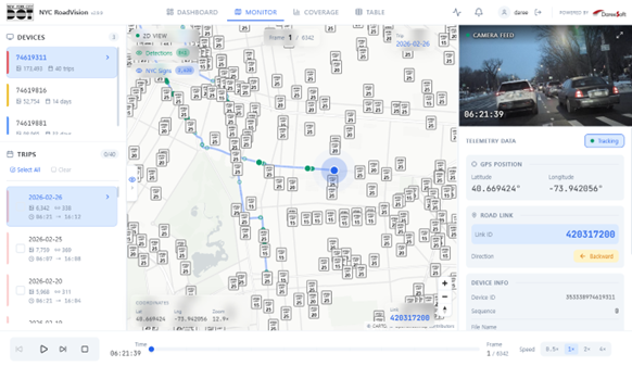
How RiaaS Closes the Trust Gap
RiaaS is designed to help agencies move from manual, periodic inspection to continuous road intelligence.
The workflow is simple:
1. Detect
Edge AI identifies road assets and conditions as the vehicle moves through the network.
2. Anchor
Each detection is tied to a precise and consistent location, so the same asset can be recognized across repeated passes.
3. Reconcile
New observations are compared against existing agency records to identify gaps, changes, and discrepancies.
This is where RiaaS becomes more than a detection tool.
If a sign is present on the road but missing from the database, the system can flag it. If a sign exists in the database but is not found on the road, the system can mark it as missing. If a sign is damaged or obstructed, the information becomes maintenance-ready.
The output is not raw video to review later. It is actionable road intelligence delivered through normal fleet operations.
What the Deployment Found
In a short operating window, the system identified and validated road sign assets across the city network using ordinary fleet vehicles, not dedicated survey trucks.
The deployment found:
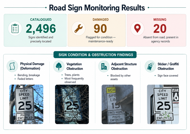 Road Sign Monitoring Results
Each result was tied to a precise coordinate and reconciled against existing records. This made the findings immediately useful for maintenance planning, asset management, and database correction.
From Periodic Surveys to Always-On Road Intelligence
Traditional road asset management works like a project: schedule a survey, collect data, update the database, and repeat later.
But roads change every day.
“With RiaaS, cities can use vehicles that are already operating — buses, maintenance vans, inspection vehicles, service fleets — to continuously monitor infrastructure as part of daily operations..”
Every route becomes a monitoring pass.
Every vehicle becomes a road intelligence sensor.
Every detection helps keep the city’s infrastructure record up to date.
This is the larger shift Dareesoft is building toward: road management that is continuous, scalable, and grounded in real-world data.
RiaaS does not simply help cities see the road. It helps them understand what has changed, where action is needed, and how to keep infrastructure records aligned with reality.
Bringing RiaaS to More Cities
Dareesoft’s RiaaS platform is designed for transportation agencies, road operators, and fleet-based organizations that need a faster, more scalable way to monitor road infrastructure.
By combining edge AI, precise positioning, and cloud-based road intelligence, RiaaS helps agencies move from reactive maintenance to continuous infrastructure awareness.
If your city or organization wants to explore how RiaaS can support road asset monitoring, sign inventory management, or broader road condition intelligence, we would be happy to discuss a pilot deployment.
 Contact us